Pull your car onto the gravel shoulder of Ochs Highway. Turn off the engine. Roll down the window and listen. Before you even open your door, you can often hear the faint sound of water moving over rock. This is Glen Falls Chattanooga. It sits on the western flank of Lookout Mountain, suspended just a few minutes above the historic St. Elmo neighborhood of Chattanooga.
Unlike the heavily advertised attractions nearby, this trail does not have a paved parking lot or a visitor center. There is no ticket booth to pass through. There is no gift shop waiting at the end. Instead, it offers a simple, functional entry point directly into the forest. It is a roadside access that feels more like a local secret than a regional destination. The lack of signage is a defining feature here. It suggests that this place belongs to those who take the time to find it.
Because it lacks the infrastructure of a state park, the experience here is raw and unfiltered. You step immediately from the asphalt of a busy mountain road onto a dirt path that winds through ancient hardwoods. The noise of the commuter traffic fades quickly, replaced by the sound of the wind in the hemlocks and the rush of the creek.
This guide covers the practical details you need to find the trailhead, park safely, and explore the upper and lower sections of the falls.
Trail Data and Vital Statistics
This table organizes the essential logistics for quick planning.
| Metric | Details |
| Trail Name | Glen Falls Trail |
| Location | Lookout Mountain, TN (Ochs Highway) |
| Trail Length/Type | Varies (Approx 1.1 miles), Out & Back |
| Elevation Gain | ~220 Feet |
| Difficulty Rating | Moderate |
| Cell Reception | Spotty (Carrier dependent) |
| ADA Accessible | No |
| Stroller Friendly | No |
| Terrain Type | Dirt, Sandstone, Roots |
| Water Fountain | No |
| Bathrooms | No |
| Pet Friendly | Yes (Leash required) |
| Fee | $0.00 |
| Parking Details | Roadside shoulder only (Limited capacity) |
| Nearby convenience store | Yes (Bottom of the mountain in St. Elmo) |
| Camping Nearby | No |
| Emergency support within 5 miles | Yes (Chattanooga metro area) |
Glen Falls Trail Chattanooga Address
One of the most common points of confusion for first-time visitors is the lack of a physical street address. The trailhead doesn’t have a mailbox, a building number, or a reception desk. It is just a pull-off in the woods, which can make plugging it into a GPS a little tricky if you don’t know what to look for.
- GPS Strategy: Avoid searching for a specific street number. Instead, type “Glen Falls Trailhead” or simply “Ochs Highway” into your navigation app. Most modern maps have the trailhead pinned accurately.
- Coordinates: If your map app is struggling or sending you to the wrong spot, you can use these approximate coordinates: 35.006, -85.344.
- Visual Landmark: You are looking for a widened gravel shoulder on Ochs Highway, roughly 1.5 miles up the mountain from St. Elmo Avenue. There is a stone wall on the left side of the road and a gap in the trees on the right.
Glen Falls Chattanooga Directions
Navigating to the trail is pretty straightforward once you know the route, but the winding mountain road requires your full attention. The road is narrow, the curves are tight, and locals tend to drive it quickly.
From St. Elmo (Bottom of the Mountain)
Most visitors approach from St. Elmo Avenue at the bottom of Lookout Mountain. Follow these steps to reach the start point:
- Turn onto Ochs Highway: From St. Elmo, take TN-58/Ochs Highway. The road climbs immediately.
- Navigate the Ascent: The road is steep and winds tightly against the mountain. You will pass the Guild Trail crossing, which is marked by overhead lights. Keep going up.
- Watch Your Speed: The limit is 30 mph. Stick to it. The lanes are narrow, and local traffic often moves quickly. Cyclists also use the climbing lane, so stay alert.
- Identify the Destination: The parking area appears on your right about 1.5 miles from the bottom. You will see a rock wall on your left and a patch of gravel shoulder on your right.
- Overshot Markers: If you see signs for Covenant College or the Sanders Crossing intersection, you have gone too far. You will need to turn around safely and come back down.
From Lookout Mountain (Top of the Mountain)
If you are coming from Rock City or Covenant College, you will be driving downhill.
- Descent: Head down Ochs Highway.
- Pass Landmarks: You will pass the Sanders Crossing trail intersection.
- Arrive: The parking area will be on your left. It is safer to drive past it, find a turnaround spot lower down, and approach it from the uphill lane to avoid crossing traffic blindly.
Glen Falls Chattanooga Parking
Parking is the main limitation for this hike. Since there is no paved lot, you have to parallel park on the gravel shoulder.
- Capacity: The shoulder has room for about 10 to 12 cars. It fills up fast on weekends.
- Positioning: Pull your car as far off the road as you can. Ochs Highway is a busy road with commercial trucks and residents. Your mirror should not hang over the white line. Fold it in if you are unsure.
- Overflow Rules: If the shoulder is full, do not squeeze in. Do not park in front of the private gates or driveways nearby. Do not park on the blind curves across the street. Police patrol this road and will ticket cars that block traffic.
- Security: This is an isolated spot. Leave nothing valuable in sight. Put your bags and electronics in the trunk before you arrive at the trailhead.
Glen Falls Trailhead
The start of the hike is subtle. Look for the simple wooden bollards (posts) that prevent cars from driving into the woods.
- Identification: Look for the gap in the trees at the center of the gravel pull-off.
- Immediate Terrain: You will step directly from gravel onto red clay dirt. The trail rises immediately, so there isn’t much of a warm-up.
- The Approach: The noise of the highway fades quickly as the mountain blocks the sound. The ground here is packed red clay and dirt. It is hard and fast when dry, but it gets slick and sticks to your shoes when wet.
- Water Bars: You will see logs buried across the trail immediately. These are meant to stop erosion. Step over them rather than on them. Wet wood is slippery and can cause a fall.
Glen Falls Chattanooga Map

While you won’t find a stack of printed maps at the trailhead, understanding the basic layout of the area helps you stay oriented.
The Trail Layout
Imagine the trail as a simple “Y” shape that has been bent slightly.
- The Stem: The main trail leads up from the road, keeping the creek on your left side.
- The Junction: Near the falls, the trail splits. The lower path goes to the base of the falls. The upper path (which looks like rock stairs) goes to the top.
- The Connection: At the very top of the falls, the trail connects to the Guild Trail, which runs horizontally across the mountain.
Key Landmarks
- The Road: This is your baseline. If you ever get turned around, heading downhill will eventually lead you back to Ochs Highway.
- The Creek: Think of this as a handrail. Keep the creek on your left as you hike up, and on your right as you hike down.
- The Power Lines: You might spot power lines cutting through the forest above the falls. These parallel the Guild Trail and can help you orient yourself if you decide to extend your hike.
Glen Falls Chattanooga Hike
The hike itself is short, but it is packed with interesting geological features. It breaks down into two distinct main sections: the Rock Door and the Cascades.
The Rock Door and Tunnel
About 0.4 miles in, the trail changes. The dirt turns into the sandstone rock of the Cumberland Plateau. You will reach a set of stone steps built into the cliff.
- The Stairs: Watch your step here. The stairs are uneven. Some are cut into the rock, and others are placed stones. Moss grows on the shaded walls.
- The Tunnel: You will soon reach the Rock Door. This is a tunnel cut through a fin of sandstone. It is about six feet high and four feet wide. Walking through it is a highlight of the hike.
- Microclimate: You will notice the temperature drop inside. The rock keeps this spot cooler than the rest of the woods.
- The Ledge: You come out onto a narrow ledge. The trail hugs the wall here. There is a drop-off into the ravine on your left. Keep your eyes on the ground.
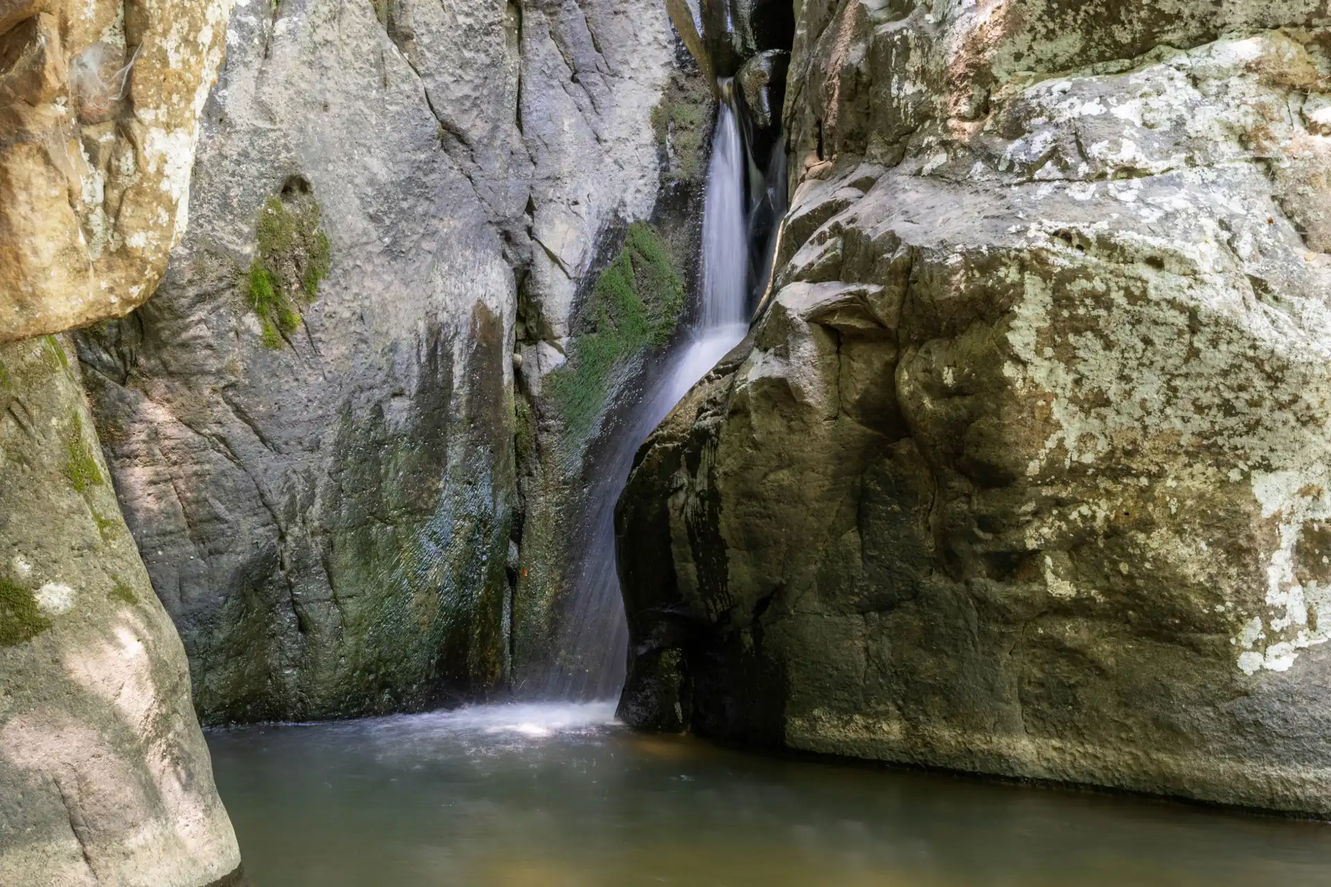
The Falls and Basin
The trail dips down after the tunnel. You arrive at the bottom of the main waterfall. The water spills over a wide rock ledge and drops about 30 feet into a pool.
- The Pool: The basin is usually shallow and full of leaves. It is not really deep enough for swimming.
- The Ground: The area is made of big flat boulders. These rocks are smooth from water and years of hikers walking on them. They are slippery even when dry and dangerous when wet.
The Upper Route
Most people stop at the bottom, but you should keep going. Look for the trail to the right of the falls. A steep set of rock stairs takes you to the top.
- The Climb: Use the stairs to reach the upper level.
- The Creek: Here, the creek flows flat across the rock before it drops over the edge.
- Crossing: You can cross the creek easily when the water is low. Just make sure you step on dry rocks.
Geology and Hydrology Analysis
It helps to know what you are walking on. Glen Falls exists because of the rock layers of Lookout Mountain.
The Rock Layers
- Warren Point Sandstone: The waterfall flows over this hard rock. It does not wash away easily, which forms the cliffs and ledges you see. It is strong enough to support the Rock Door without collapsing.
- The Undercut: Under the sandstone is softer shale and limestone. Water wears away this softer rock faster than the hard sandstone on top. This creates the overhangs and small caves near the falls.
The Soil and Water Flow
The flow of Glen Falls depends entirely on rain. The area that drains into the creek is small. It does not pull from a big river. It only drains a small part of the mountain.
- Flashy Nature: The stream rises fast and drops fast.
- Rain Event: Water hits the ground above.
- Runoff: The rock does not let water soak in deep, so it runs across the surface.
- Peak Flow: The falls will be heavy for a day or two after a storm.
- Dry Spells: If it has not rained in two weeks, the falls might just be a trickle.
Seasonal Conditions Guide
The hike changes a lot depending on the season. Here is what to expect throughout the year.
Winter (December through February)
- Overview: The water is highest in winter. The trees have no leaves, so you can see through the woods clearly.
- Hazards: Ice is a real issue. The spray from the falls freezes on the rocks. The stone steps can turn into ice sheets.
- Gear: You might need traction devices like microspikes if it is freezing.
- Crowds: This is the quietest time to visit.
Spring (March through May)
- Overview: The rain keeps the waterfall flowing. The forest floor turns green with wildflowers like Trillium.
- Hazards: Mud is the main problem. The lower trail can be very slippery.
- Gear: Wear waterproof boots.
- Crowds: Expect to see more people on weekends.
Summer (June through August)
- Overview: The water often slows down or stops. Locals call it “Glen Drips” when it gets dry. The trees provide full shade, which helps with the heat.
- Hazards: The air in the ravine can feel heavy and humid. Mosquitoes breed in the still pools.
- Gear: Bring bug spray.
- Crowds: The shade attracts people looking to escape the city heat.
Fall (October through November)
- Overview: The forest turns red and orange. It is a beautiful time for photography.
- Hazards: Fallen leaves hide the roots and rocks on the trail. Dry leaves on smooth rock can be as slippery as ice.
- Crowds: This is peak season for Ochs Highway. Expect the parking to be full.
What Lives in These Woods

You are walking through a specific type of forest called the Cumberland Plateau escarpment. It is a living ecosystem, so here is what to keep an eye out for.
- Eastern Hemlock: These are the large evergreen trees with short needles and rough bark. They grow along the creek banks because they love the cool, damp air in the ravine.
- Tulip Poplar: Look for tall, straight trunks and unique leaves shaped a bit like a cat’s face. These giants grow fast in spots where old trees have fallen and opened up sunlight.
- Salamanders: The wet rocks are a haven for salamanders. You might spot them under leaves or near the water’s edge. Just look, don’t touch. The oils on our hands can hurt their sensitive skin.
- Birds: Pileated Woodpeckers are common here; you’ll likely hear their loud, laughing calls before you see them. Barred Owls also hunt in this ravine, and you might hear their distinct “Who-cooks-for-you?” call, especially late in the afternoon.
Safety Protocols
This is not a dangerous mountain climb, but you still need to be careful. Most injuries here happen when people slip on wet rocks.
- Test Footing: Always test a rock before you put your full weight on it.
- Knees Bent: Keep your knees bent when you go down the stone stairs.
- No Jumping: Do not try to jump between boulders. A twisted ankle here is a problem because there is no easy way out.
- Water Safety: Do not drink from the creek without a filter. Do not swim in the pools.
- Private Property: The trail is on public land, but the woods around it are private. Do not walk off the trail. Respect the property lines.
Equipment Checklist

You do not need much gear, but you should bring the right things.
- Footwear: Wear trail runners or light hiking boots. Smooth sneakers will slide on the wet rock. Sandals are a bad idea because of roots and poison ivy.
- Water: Bring a bottle of water for each person.
- Light: If you hike late in the day, bring a headlamp. The woods get dark before the sun actually sets.
- Traction (Winter): Micro-spikes help on icy stairs.
- Trekking Poles (Optional): These help with balance on the stone steps.
Post-Hike Logistics and St. Elmo
When you are done hiking, you are close to St. Elmo. It is a good spot to grab food.
- Getting There: Turn left out of the parking spot to go downhill. Drive 1.5 miles. The road flattens out at the bottom. You are now in the historic district.
- Plus Coffee: This is on St. Elmo Ave. They serve good espresso.
- The Tap House: A good spot for burgers and local beer.
- Clumpies Ice Cream: This is a famous local spot near the Incline Railway station.
- Grocery: There is a Publix grocery store further down Broad Street.
- Supplies: Ace Hardware in St. Elmo has basic outdoor supplies if you need something.
People Also Ask
The hike is approximately 1.1 miles round-trip. It is an out-and-back trail, meaning you’ll hike to the falls (and potentially up to the Guild Trail) and return the same way you came.
No, Glen Falls is not a swimming hole. The basin at the bottom of the falls is usually shallow, filled with leaves and sediment. While you can wade or splash your feet in the creek, it isn’t deep enough for swimming.
The trail is rated as Moderate. While it is short, it features uneven stone stairs, roots, and a narrow “rock door” tunnel. It is not ADA accessible or stroller-friendly, and the terrain can be very slippery when wet.
There is no paved parking lot. You must park on the gravel shoulder of Ochs Highway (TN-58). Look for the rock wall on the uphill side and pull completely off the asphalt to avoid obstructing mountain traffic.
It’s important to distinguish the two: Waterfall Glen (located in Illinois) features a 9.5-mile loop. Glen Falls in Chattanooga is an out-and-back trail roughly 1 mile long.
While Great Falls Park (in Virginia) charges an entrance fee, Glen Falls in Chattanooga is completely free. There are no permits, tickets, or parking fees required to enjoy this trail.
In Conclusion
Glen Falls serves as a powerful reminder of why Chattanooga is such a unique place to live and visit. You can drive fifteen minutes from the center of a mid-sized city and find yourself standing in a sandstone tunnel surrounded by ancient hemlocks. It bridges the gap between the urban and the wild in a way that feels seamless.
The trail rewards consistency. If you visit once in July, you might see a dry creek and a shady walk. If you return in February, you might find a roaring cascade and ice clinging to the cliffs. It teaches you to pay attention to the weather and the seasons. It encourages you to return to the same spot multiple times to see how the land changes.
This hike also represents the democratic nature of the outdoors in this region. There is no gatekeeper here, and there is no entrance fee. There is no reservation system. You simply need to find a parking spot and start walking. That accessibility is rare in an era where many natural spaces are becoming increasingly regulated and monetized.
However, that freedom comes with responsibility. Because there is no staff to clean up the trail, the condition of Glen Falls depends entirely on the people who use it. It relies on hikers to pack out their trash and stay on the marked path. It relies on visitors to respect the neighbors who live just through the trees.
Glen Falls is not the biggest waterfall in Tennessee. It is not the highest overlook on Lookout Mountain. But it is perhaps the most charming. It is a quiet, reliable escape that asks for nothing but your attention. When you need to reset, check your gas, lace up your shoes, and go!